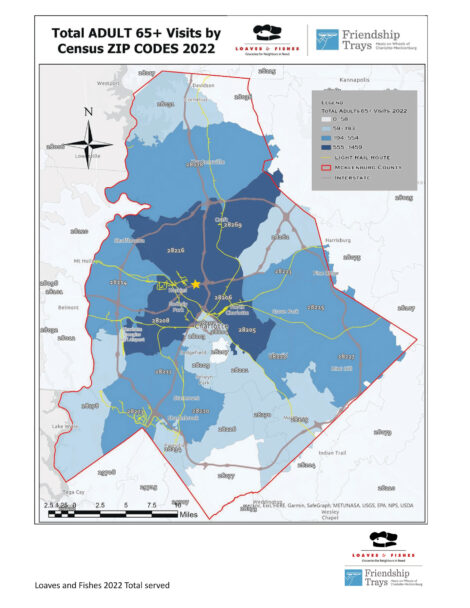
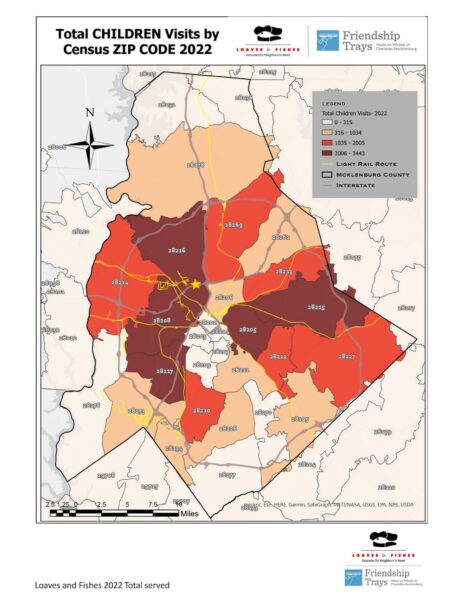
Heat Maps of Grocery Client Data Shows Where Food Insecurity is Concentrated in Mecklenburg Co.
A shocking increase in clients served from 2021 to 2022.
This year, we began a partnership with the UNC Charlotte geography department. They were able to analyze our 2022 grocery client data and map it out according to zip code, census tract and block groups as well as break it down by age group. The maps indicate heavy rates of food insecurity all around the “crescent” of poverty that surrounds uptown Charlotte.
In this comparison of the data from 2021 to 2022 you can see that the darker the color, the higher the rate of food insecurity in that zip code. In the map on the right, you will notice a yellow star in the center of the crescent located in zip code 28216. This is the location of our new warehouse and administrative offices – the Loaves & Fishes/Friendship Trays Hunger Hub of Hope – opening in early 2024! Moving our operations to the heart of the food insecurity crescent in 28216, the Thomasboro-Hoskins neighborhood, allows us to expand access.
Nearly 50% of the people we fed are children and seniors
- 38% more people served through our pantries and home grocery delivery.
- 35% more people served at Food Shares.
- Meals on Wheels delivered 133,000 meals to recipients’ doors in 2022 compared to 117,000 in 2021, a 13% increase.
- 47% of our recipients are Black
- 37% are Latino